NASA
© 2008 Ellesmere Ice Shelves
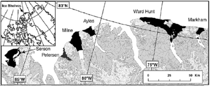
The six ice shelves along the northern Ellesmere coastline, High Arctic Canada, in 2004 (Mueller et al. 2006). The Ayles Ice Shelf broke out in August 2005.
Ice Shelves
There has been a >90% decline in the area of ice shelves along northern Ellesmere Island over the last century. The aim of the measurements during the Ranger patrol in April 2008 is to provide a baseline against which past and future changes can be assessed. Ice-penetrating radar will be used to measure ice depths across the Serson, Petersen, and Milne ice shelves, together with the depths of old multi-year landfast sea ice in the fiords along this coastline. For the Serson and Petersen ice shelves this will be the first ever measurements of their thicknesses; for the Milne it will enable comparisons with ice depths previously measured in the 1960s and 1980s. A new network of mass balance stakes will be established across these ice shelves to provide a record of their long-term surface melt and snow accumulation rates. An existing network of mass balance stakes will be measured on the Ward Hunt Ice Shelf and Ice Rise.
In addition, a new satellite tracking beacon (provided by the Canadian Ice Service) will be deployed on the second piece of the Ayles Ice Island after it broke in half in the fall of 2007 (Copland et al. 2007). A satellite-connected climate station will also be installed on near the Serson Ice Shelf. This permanent station will provide a continuous record of the climate in this region, with the data available in real-time at the Serson Ice Shelf, Northern Ellesmere Island weather data website.
Principal Investigators
Dr. Luke Copland University of Ottawa
Dr. Derek Mueller Trent University